New paper on rethinking bikeability indexes using multi-criteria analysis techniques

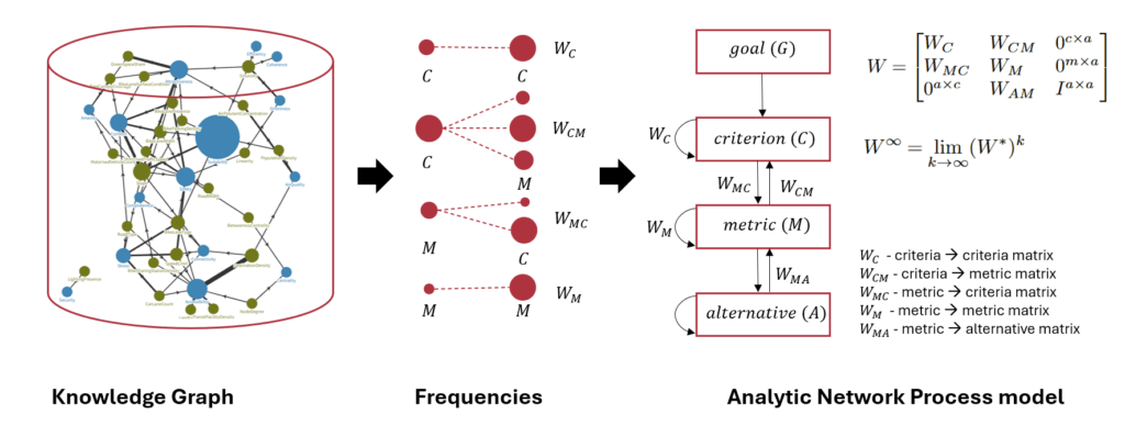
Our new paper, “Rethinking Bikeability Indexes: Fusing Knowledge Graph and MCDA Technique for Multi-criteria Bike Network Evaluations,” was presented by Ayda Grisiute at the 28th AGILE Conference on Geographic Information Science, 10–13 June 2025. It introduces a novel method for evaluating bike infrastructure by integrating a curated knowledge graph of bikeability metrics with the Analytic Network Process (ANP), a decision modelling technique.

The study addresses limitations in current bikeability indexes, which often oversimplify how different metrics interact. By combining over 270 metrics and 41 qualitative criteria from global studies with ANP’s ability to model interdependencies, our approach offers a more rigorous and transparent way to evaluate cycling networks. Applied to Zurich’s road network, the method produces a segment-level bikeability index and includes sensitivity analysis to assess the robustness of results under structural changes.

Check out our paper and the corresponding code on Github!

New paper on 3D land use planning for making the future cities measurable

Our paper “3D Land Use Planning: Making Future Cities Measurable with Ontology-Driven Representations of Planning Regulations” was presented by Ayda Grisiute at the 28th AGILE Conference on Geographic Information Science, 10–13 June 2025. The work addresses the challenge of evaluating long-term urban strategies by transforming fragmented and inconsistent planning regulations into a unified, machine-readable knowledge graph.

The core contribution is the development of two ontologies: OntoPlanningRegulations and OntoBuildableSpace. Two ontologies connect urban planning rules to 3D city models, enabling scalable analysis of regulatory impacts at scale. This approach powers city-wide estimation of allowable Gross Floor Areas (GFAs) across Singapore and supports applications such as automated site search via a developed Programmatic Plot Finder tool.

We demonstrate how formalized planning data can be used to quantify urban form, simulate regulatory changes, and improve transparency in urban development processes.

Check out our paper and the corresponding code on Github!

New study published in Transportation Research Interdisciplinary Perspectives

Our paper on “A causal intervention framework for synthesizing mobility data and evaluating predictive neural networks” has been published open-source in Transportation Research Interdisciplinary Perspectives!

We introduced a Causal Intervention Framework that enables controlled manipulation of mobility-related behavior in synthetic location sequences. This enables us to evaluate how specific behaviors influence the performance of next-location prediction models.

We hope this offers a foundation for future research at the intersection of mobility modeling, interpretation, and explainable AI.

Check out the paper online and the corresponding code on Github!

New paper on evaluating spatio-temporal predictions with Optimal Transport

Our paper “GeOT: A spatially explicit framework for evaluating spatio-temporal predictions”, is now published in the International Journal of Geographical Information Science (IJGIS)!

Motivation: While the GIS mantra “spatial is special” is widely acknowledged, it has not made its way into how we evaluate spatio-temporal predictions. Standard error metrics like MSE or MAE are typically averaged over locations, ignore the spatial structure of the data.

Contribution: To close this gap, we propose to leverage Optimal Transport (OT), a theoretical framework to compare two distributions. With OT, we can measure the difference between the true and predicted spatial distribution by computing the minimal transportation costs to align them.

Results: We show that our GeOT framework 1) effectively measures the spatial quality of predictions, 2) relates to spatial autocorrelation, and 3) provides interpretable results. On top of that, this approach is not just a new spatial evaluation metric – it can also be integrated as a loss function in machine learning tasks.

Check out our paper and code base with tutorials.

New paper on context-aware knowledge graph framework for traffic forecasting

Our new paper, titled “Context-Aware Knowledge Graph Framework for Traffic Speed Forecasting Using Graph Neural Networks,” has been accepted for publication in IEEE Transactions on Intelligent Transportation Systems.

This paper introduces a novel context-aware knowledge graph (CKG) framework to enhance traffic speed forecasting by effectively modeling spatial and temporal contexts. Using a relation-dependent integration strategy, the framework generates context-aware representations that capture the intricate spatio-temporal dependencies of urban environments.

Building on this foundation, a CKG-GNN model is developed, integrating the CKG, dual-view multi-head self-attention mechanisms, and graph neural networks (GNNs). This integration not only significantly improves predictive accuracy but also underscores the importance of contextual information in forecasting traffic dynamics.

By bridging domain knowledge with graph neural architectures, the proposed approach demonstrates its potential for advancing intelligent transportation systems.

Please check our paper and codes.

🚴 Join Our Cycling Experience Survey! 🚴

We’re exploring how people perceive cycling routes and what shapes their cycling experience.

What will you do?
• Watch short cycling videos.
• Answer brief questionnaires about your experience.

Who can join?
✔ 18 years or older.
✔ Moderate proficiency in English.
✔ Normal eyesight (contact lenses allowed).

Why participate?
• Contribute to research that improves cycling experiences.
• Your responses will remain completely anonymous.

Ready to roll?
Then scan the QR code or click on the link to the survey: https://lnkd.in/eK_q62uF

New paper on optimal bike network planning

Our paper Bike Network Planning in Limited Urban Space was accepted for publication in Transportation Research Part B: Methodological!

This paper was part of the e-bike city project, a multidisciplinary initiative at the department exploring the effects of a radically changed urban road space with priority on cycling. Planning a suitable bike network is a core challenge in this project. In our paper, we introduce a novel optimization method for placing new bike lanes with minimal impact on other travel modes.

Our approach leverages the concept of Pareto-optimality: When car lanes are repurposed as bike lanes, car travel times inevitably increase. The key question is: By how much? Pareto-optimal solutions are the street networks that present the best trade-off between car accessibility and bikeability. To quantify bikeability, we introduce the concept of “perceived bike travel time”, based on research showing that cyclists perceive dedicated bike lanes as faster. Our experiments show that the optimization approach outperforms other methods by proposing networks that have both lower car travel times and lower perceived bike travel times.

Check out our paper or get in touch if you are interested to know more!

Further resources:

A New Tool for Transforming Urban Transportation Systems Without Building New Roads

A new paper titled “Designing an E-Bike City: An automated process for network-wide multimodal road space reallocation” was published in the Journal of Cycling and Micromobility Research.

How can we add transport capacity for rapidly growing urban populations? How can urban transportation systems be transformed for lower emissions within the short time available? In dense cities, adding transport infrastructure is expensive, takes many years of construction, and faces restrictions by historical buildings. Our research proposes a faster and cheaper approach: We have developed an automated tool that redesigns urban transportation systems only by reorganizing lanes on existing roads.

The SNMan – Street Network Manipulator is a new open-source software that allows researchers and planners to generate alternative transportation networks within existing road space. It can handle any scale, from individual blocks to entire cities. Depending on the goals set, it can add bike lanes, bus lanes, or green spaces, while reorganizing the rest so that buildings remain accessible by car and public transit remains functional. For example, Zurich’s roads could allocate 4x more space for cycling infrastructure while still satisfying these conditions.

Discover more in the recently published open-access paper!

Design steps applied to a single block.

New Paper on Understanding Complexity of Urban Traffic Prediction

A new paper titled “Enhancing Deep Learning-Based City-Wide Traffic Prediction Pipelines Through Complexity Analysis” was published in the journal Data Science for Transportation.

Our research introduces a novel metric that allows for the pre-modelling complexity evaluation of traffic prediction tasks. This metric, designed for computational efficiency and to be architecture-agnostic, assists in choosing the most suitable model for specific traffic scenarios. It advocates a shift from the traditional “bigger-is-better” approach in deep learning-based traffic prediction to a “just-enough” complexity model, optimizing both performance and resource utilization.

The findings enable a refined approach to modelling traffic prediction tasks, such as deciding between multiple chained predictions and a single-shot prediction. Furthermore, it allows for the segmentation of urban areas into regions of varying complexity, paving the way for deploying ensembles of models that better address diverse urban dynamics.

For more details on this transformative approach and its potential impacts on urban traffic management, check out our paper!

The same model, when trained on two datasets with differing intrinsic traffic complexities, achieves varying levels of effective model complexity during training.

Spatial Nudging framework presented at COSIT 2024 conference

A new paper, titled “Spatial Nudging: Converging Persuasive Technologies, Spatial Design, and Behavioral Theories”, was presented at the 16th International Conference on Spatial Information Theory (COSIT 2024).

This paper introduces the Spatial Nudging framework—a theory-driven approach that maps out nudging strategies in the mobility domain, with a focus on cycling. The framework integrates physical and digital interventions to promote sustainable mobility, drawing from behavioral theories such as Nudge Theory and the Theory of Affordances. Additionally, we propose a graph-based workflow that uses cognitive graphs and the Fine-to-Coarse heuristic to model how cyclists perceive their environment. This method generates cognitive routes that align perceived affordances with the physical environment, closely resembling real-world cycling trajectories.

For more details, check out our paper!