New IJGIS Paper is online – using context data to improve traffic forecasting

Our new paper entitled “Incorporating multimodal context information into traffic speed forecasting through graph deep learning” is now online at IJGIS.

In this work, we propose a multimodal context-based graph convolutional neural network (MCGCN) model to fuse context data into traffic speed prediction, including spatial and temporal contexts. The proposed model comprises three modules, i.e., (a) hierarchical spatial embedding to learn spatial representations by organizing spatial contexts from different dimensions, (b) multivariate temporal modeling to learn temporal representations by capturing dependencies of multivariate temporal contexts and (c) attention-based multimodal fusion to integrate traffic speed with the spatial and temporal context representations for multi-step speed prediction. We conduct extensive experiments in Singapore. Compared to the baseline model (STGCN), our results demonstrate the importance of multimodal contexts with the mean-absolute-error improvement of 0.29 km/h, 0.45 km/h and 0.89 km/h in 30-min, 60-min and 120-min speed prediction, respectively. We also explore how different contexts affect traffic speed forecasting, providing references for stakeholders to understand the relationship between context information and transportation systems. Check out the open-access paper online!

Paper published in the Journal of LBS

Our paper titled “Influence of tracking duration on the privacy of individual mobility graphs” was published by the Journal of Location Based Services! In this work, we use a GPS tracking dataset and analyze how the tracking duration affects the risk for users to be re-identified; i.e., by matching to previously stored tracking data. It is well known that the tracking data of a user is quite unique and can be matched to stored data easily; however, we study the risk of a representation of tracking data that is already privatised, namely so-called location graphs. Location graphs do not reveal the geocoordinates or time stamps of the places that a user visited, but just the topology of the mobility behaviour. Nevertheless, users can be re-identified with a top-1 accuracy of up to 20%, and the re-identification risk strongly depends on the tracking duration of the user, as well as the duration of the stored data (pool), as shown in the figure below. Check out our paper and code for more information!

Welcome Ayda Grisiute to MIE Lab!

Ayda Grisiute joins MIE Lab on May 1st as a Ph.D. student. Before joining MIE Lab, Ayda worked as a researcher at Singapore-ETH Centre for the Cities Knowledge Graph project. Ayda has a background in architecture and city planning. She received her master’s degree in Architecture from Aalto University, Finland, and her bachelor’s degree in Architecture from Vilnius Academy of Arts, Lithuania. In her previous studies, Ayda focused on algorithmic and data-driven design methodologies. Ayda is excited about urban knowledge management and representation with graphs and she is looking forward to an amazing journey at MIE Lab. We are happy to have her join the team!

The Open Digital Twin Platform Project Kick-Off Event

On March 30th the kick-off event for the project “An Open Digital Twin Platform for Research on the Swiss Mobility System” (ODTPR-SMS) took place at the LEE building together with our research partners at the Institute for Transport Planning and Systems, the Swiss Data Science Center and the Center for Sustainable Future Mobility. In the latter, the Geoinformation-Engineering group is a key stakeholder. The project is part of the Swiss National Strategy and Action Plan for Open Research Data and funded by swissuniversities through a Swiss Open Research Data Grant and has been acquired by our lab member Jascha Grübel. ODTPR-SMS has been funded with 1.5 million CHF (matched funding) to develop an Open Digital Twin Platform to underpin development on a mobility-specific Digital Twin “CH on the move”. In the kick-off meeting, all involved parties agreed on the timeline, distributed tasks, discussed the licensing of the software and got to know each other. Everybody was thrilled to contribute to strategically important tool chain that will be developed in the coming 24 months. As part of the project, 2 postdocs will join us at the Center for Sustainable Future Mobility to develop key features of the system.

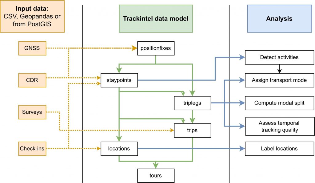
The Open Digital Twin Platform (ODTP) is bringing together cloud computing, data semantics, licensing, access control and visualisation to enable a holistic processing of data covering data acquisition, data representation, data processing, data analysis and data visualisation. Known tools for mobility research can be automated within ODTP to provide (micro-)services and apply to new scenarios with less overhead than ever before. ODTP takes care of the provisioning and deployment of software allowing researchers to focus on their scientific questions rather than how to get the technology working. To quickly assemble a new Digital Twin, ODTP makes use of a “Digital Twin Zoo” that hosts key software as containers readied to be micro-services. Throughout our project ODTPR-SMS, we will develop a first set of mobility related micro-services that include well-known tools such as MATSim, eqasim and our own trackintel. We are also making available as many data sources on Swiss mobility as possible starting with the National Data Infrastructure for Mobility (NaDIM).


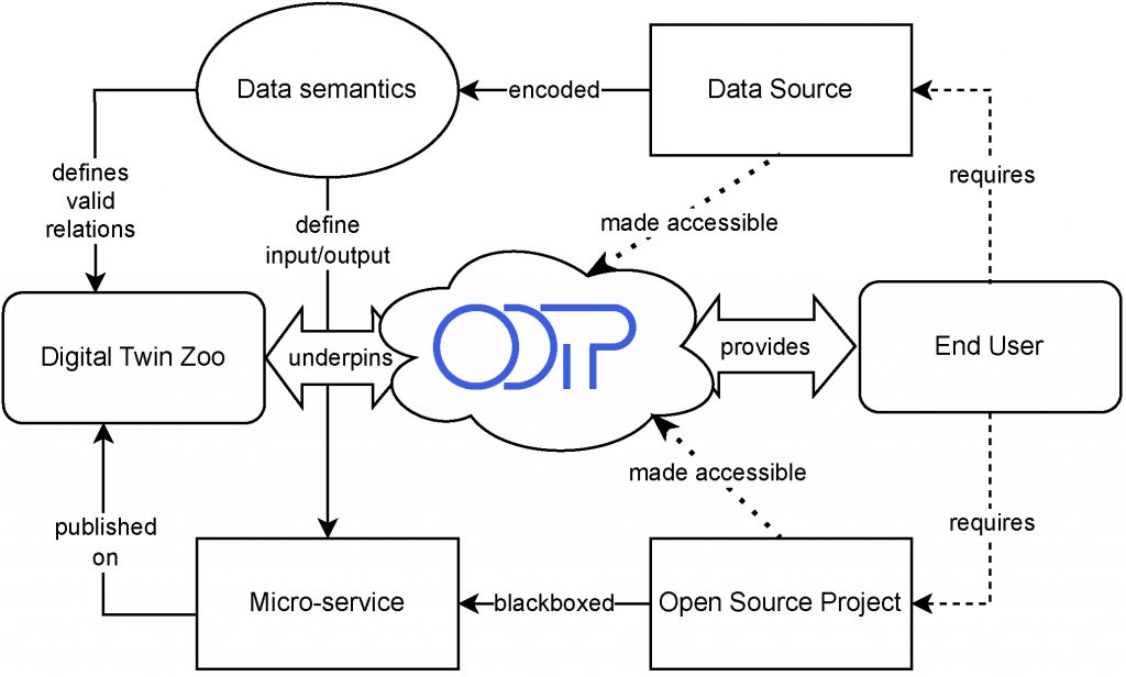
Figure: Overview of ODTP for end users. ODTP facilitates access to open-source software and data through a container-based backend and hosting infrastructure.

ODTP will be accompanied by an open standard for digital twinning. We are looking for experts to evaluate our platform and if you are interested in mobility, digital twins or a combination thereof, please contact Jascha Grübel (jgruebel@ethz.ch) for details on how to join our evaluation board which will be published at the Center of Sustainable Future Mobility’s website. We are also looking forward to add more mobility related software tools to ODTP and we are interested to discuss potential new services, again please contact Jascha Grübel for more details (jgruebel@ethz.ch).

Reference: Grübel, J., C. Vivar Rios, M. Balać, Y. Xin, R. M. Franken, S. Ossey, M. Raubal, K. W. Axhausen and O. Riba-Grofnuz (2023a) “CH on the move”: Introducing the Prototype Digital Twin of The Swiss Mobility System, paper presented at the Swiss Transport Research Conference 2023.

New CEUS paper published – presenting our open-source library Trackintel

Over the past years, MIE lab has been developing an open-source Python library for analyzing human mobility data. Trackintel provides a standardized pipeline for loading, preprocessing, and analyzing tracking data, as shown in the graphic below.  In the paper titled “Trackintel: An open-source Python library for human mobility analysis”, we describe the functionality of the library and demonstrate it in a case study on several datasets.
The paper is available open-access.

New TR_C paper online – “Conserved quantities in human mobility”

Our new paper entitled “Conserved quantities in human mobility: From locations to trips” was accepted at Transportation Research Part C: Emerging Technologies and is now available online.

We use two high-resolution user-labelled datasets from ~3800 individuals to analyse individuals’ activity–travel behaviour over the long term. We find that individuals maintain a conserved quantity in the number of essential travel mode and activity location combinations over time. A typical individual maintains 15 mode–location combinations, of which 7 are travelled with a private vehicle every 5 weeks. The dynamics of this stability reveal that the exploration speed of locations is faster than the one for travel modes, and they can both be well-modelled using a power-law fit that slows down over time.

Our findings enrich the understanding of the long-term intra-person variability in activity–travel behaviour and open new possibilities for designing mobility simulation models.

Check out the open-access paper online!

New CEUS paper online: “Graph based mobility profiling”

Our new paper on “Graph based mobility profiling” was accepted at Computers, Environment and Urban Systems (CEUS) and is now available online. We propose a graph based workflow to identify groups of persons with similar mobility behavior based on person specific graphs that describe the mobility behavior. Our approach is privacy friendly, does not depend on a specific clustering algorithm, is robust against the choice of hyperparameters, does not require specific labels in the dataset, and is not limited to specific types of tracking data. We show in the paper how this can be used to evaluate the impact of new mobility offers.

The paper is open access and the source code of the project is available on our Github.

New TGIS Paper is Online – “Street-level Traffic Flow and Context Sensing Analysis”

Our new paper entitled “Street-level traffic flow and context sensing analysis through semantic integration of multisource geospatial data” by Yatao Zhang and Martin Raubal is now online at TGIS.

Sensing urban spaces from multisource geospatial data is vital to understanding the transportation system in the urban context. However, the complexity of urban context and its indirect interaction with traffic flow deepen the difficulty of exploring their relationship. This study proposes a geo-semantic framework first to generate semantic representations of multi-hierarchical urban context and street-level traffic flow, and then investigate their mutual correlation and predictability using a novel semantic matching method. The results demonstrate that each street is associated with its multi-hierarchical spatial signatures of urban context and street-level temporal signatures of traffic flow. The correlation between urban context and traffic flow displays higher values after semantic matching than those in multi-hierarchies. Moreover, we found that utilizing traffic flow to predict urban context results in better accuracy than the reversed prediction. The results of signature analysis and relationship exploration can contribute to a deeper understanding of context-aware transportation research.