New paper on rethinking bikeability indexes using multi-criteria analysis techniques

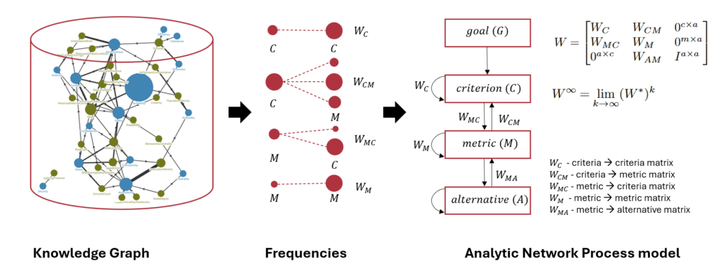
Our new paper, “Rethinking Bikeability Indexes: Fusing Knowledge Graph and MCDA Technique for Multi-criteria Bike Network Evaluations,” was presented by Ayda Grisiute at the 28th AGILE Conference on Geographic Information Science, 10–13 June 2025. It introduces a novel method for evaluating bike infrastructure by integrating a curated knowledge graph of bikeability metrics with the Analytic Network Process (ANP), a decision modelling technique.

The study addresses limitations in current bikeability indexes, which often oversimplify how different metrics interact. By combining over 270 metrics and 41 qualitative criteria from global studies with ANP’s ability to model interdependencies, our approach offers a more rigorous and transparent way to evaluate cycling networks. Applied to Zurich’s road network, the method produces a segment-level bikeability index and includes sensitivity analysis to assess the robustness of results under structural changes.

Check out our paper and the corresponding code on Github!
New paper on 3D land use planning for making the future cities measurable

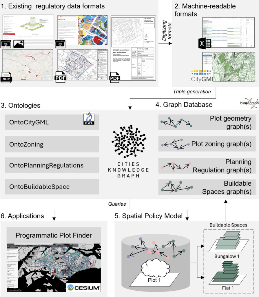
Our paper “3D Land Use Planning: Making Future Cities Measurable with Ontology-Driven Representations of Planning Regulations” was presented by Ayda Grisiute at the 28th AGILE Conference on Geographic Information Science, 10–13 June 2025. The work addresses the challenge of evaluating long-term urban strategies by transforming fragmented and inconsistent planning regulations into a unified, machine-readable knowledge graph.

The core contribution is the development of two ontologies: OntoPlanningRegulations and OntoBuildableSpace. Two ontologies connect urban planning rules to 3D city models, enabling scalable analysis of regulatory impacts at scale. This approach powers city-wide estimation of allowable Gross Floor Areas (GFAs) across Singapore and supports applications such as automated site search via a developed Programmatic Plot Finder tool.

We demonstrate how formalized planning data can be used to quantify urban form, simulate regulatory changes, and improve transparency in urban development processes.

Check out our paper and the corresponding code on Github!
🚴 Join Our Cycling Experience Survey! 🚴

We’re exploring how people perceive cycling routes and what shapes their cycling experience.

What will you do?
• Watch short cycling videos.
• Answer brief questionnaires about your experience.

Who can join?
✔ 18 years or older.
✔ Moderate proficiency in English.
✔ Normal eyesight (contact lenses allowed).

Why participate?
• Contribute to research that improves cycling experiences.
• Your responses will remain completely anonymous.

Ready to roll?
Then scan the QR code or click on the link to the survey: https://lnkd.in/eK_q62uF

Spatial Nudging framework presented at COSIT 2024 conference

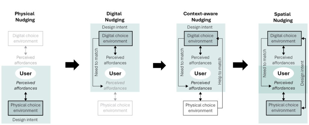
A new paper, titled “Spatial Nudging: Converging Persuasive Technologies, Spatial Design, and Behavioral Theories”, was presented at the 16th International Conference on Spatial Information Theory (COSIT 2024).

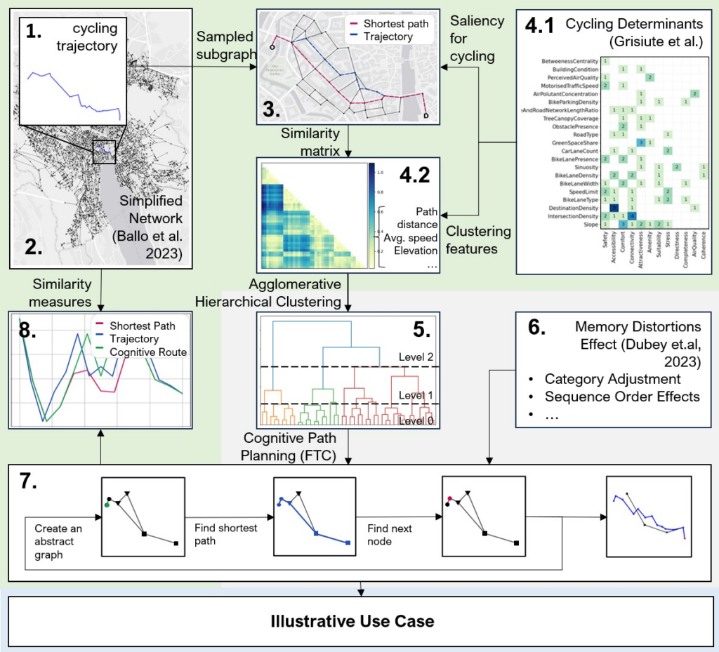
This paper introduces the Spatial Nudging framework—a theory-driven approach that maps out nudging strategies in the mobility domain, with a focus on cycling. The framework integrates physical and digital interventions to promote sustainable mobility, drawing from behavioral theories such as Nudge Theory and the Theory of Affordances. Additionally, we propose a graph-based workflow that uses cognitive graphs and the Fine-to-Coarse heuristic to model how cyclists perceive their environment. This method generates cognitive routes that align perceived affordances with the physical environment, closely resembling real-world cycling trajectories.

For more details, check out our paper!

Ayda Grisiute presented at CRBAM 2024

Ayda Grisiute gave a talk at the 8th Cycling Research Board Meeting (CRBAM). The presentation, titled “Conceptualizing Spatial Nudging: A Theoretical Framework for Integrating Interventions to Promote Cycling“ introduced Spatial Nudging framework that delineates nudging practices in the mobility domain and offers a theoretically integrated perspective on promoting cycling through spatial interventions.

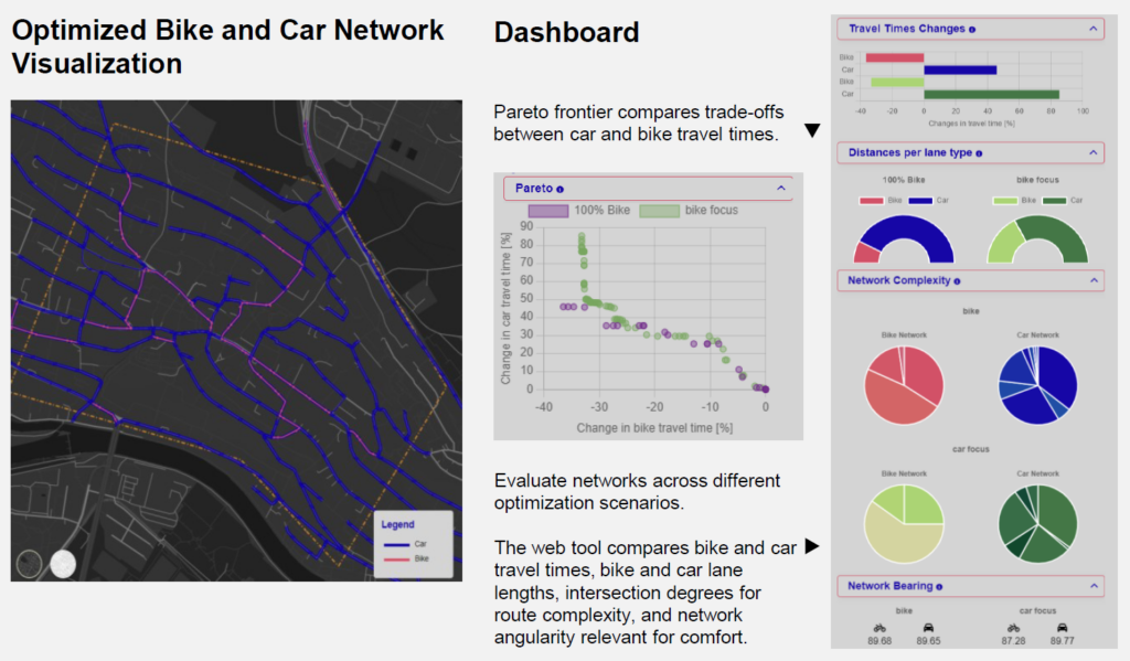
In addition, Ayda presented a poster titled “Building a Planning Tool for the E-Bike City Vision,” which showcased a web application created by two geomatics students. The tool helps urban planners reallocate road space for bike lanes using various optimization strategies.

Check out the poster here!

New paper in Computers, Environment and Urban Systems: introducing VeloNEMO ontology to harmonize bike network evaluations

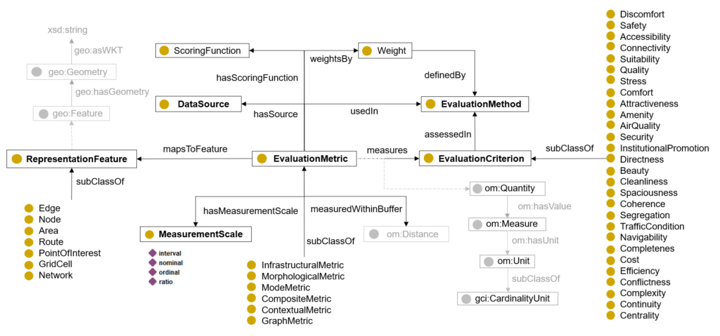
As the ecosystem of transport planning and evaluation metrics, tools, methods, and services grows, there is a pressing need to enhance domain interoperability and interpretability. In our new paper, titled “An ontology-based approach for harmonizing metrics in bike network evaluations“ , we construct a formal ontology, VeloNEMO, a formal ontology designed to capture the key attributes of bike network evaluation metrics and resolve terminological inconsistencies across them. We also introduce a machine-readable knowledge graph that compiles existing metrics, allowing for more efficient meta-analyses of various evaluation strategies. To further enhance transparency, we offer recommendations for making metric descriptions more comparable across different evaluation approaches.

For more details, check out our paper!