New paper on evaluating spatio-temporal predictions with Optimal Transport

Our paper “GeOT: A spatially explicit framework for evaluating spatio-temporal predictions”, is now published in the International Journal of Geographical Information Science (IJGIS)!

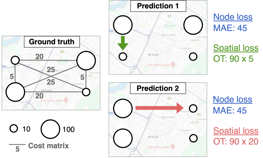
Motivation: While the GIS mantra “spatial is special” is widely acknowledged, it has not made its way into how we evaluate spatio-temporal predictions. Standard error metrics like MSE or MAE are typically averaged over locations, ignore the spatial structure of the data.

Contribution: To close this gap, we propose to leverage Optimal Transport (OT), a theoretical framework to compare two distributions. With OT, we can measure the difference between the true and predicted spatial distribution by computing the minimal transportation costs to align them.

Results: We show that our GeOT framework 1) effectively measures the spatial quality of predictions, 2) relates to spatial autocorrelation, and 3) provides interpretable results. On top of that, this approach is not just a new spatial evaluation metric – it can also be integrated as a loss function in machine learning tasks.

Check out our paper and code base with tutorials.

New paper on optimal bike network planning

Our paper Bike Network Planning in Limited Urban Space was accepted for publication in Transportation Research Part B: Methodological!

This paper was part of the e-bike city project, a multidisciplinary initiative at the department exploring the effects of a radically changed urban road space with priority on cycling. Planning a suitable bike network is a core challenge in this project. In our paper, we introduce a novel optimization method for placing new bike lanes with minimal impact on other travel modes.

Our approach leverages the concept of Pareto-optimality: When car lanes are repurposed as bike lanes, car travel times inevitably increase. The key question is: By how much? Pareto-optimal solutions are the street networks that present the best trade-off between car accessibility and bikeability. To quantify bikeability, we introduce the concept of “perceived bike travel time”, based on research showing that cyclists perceive dedicated bike lanes as faster. Our experiments show that the optimization approach outperforms other methods by proposing networks that have both lower car travel times and lower perceived bike travel times.

Check out our paper or get in touch if you are interested to know more!

Further resources:

We invite you to join our workshop on Reproducibility in Tracking Data Analysis and Mobility Research at ACM SIGSPATIAL

This year at the ACM SIGSPATIAL conference, we are hosting a workshop on Reproducibility in Tracking Data Analysis and Mobility Research (https://github.com/mie-lab/reprotrack)!

Considering the fast methodological advances in spatial data science, the topic of reproducibility is more important than ever before. To foster common standards and transparency, we aim to bring researchers together in this session to discuss challenges and future pathways for reproducible spatial data science, with a focus on mobility data. The workshop is planned as a particularly interactive session, including a hands-on tutorial on tracking data preprocessing where you can bring your own data.

Please sign up here if you plan to attend the workshop. We hope to see you there on Monday, November 13th, in Hamburg!