MIE-Lab members attended the Zürich Mobility Data Workshop sponsored by IARAI at the University of Zürich on July 20th. The workshop brought together researchers based in Zurich that work on different mobility research topics to discuss the results and insights learned in the NeurIPS Traffic4cast competition series organized by IARAI. The workshop sparked a lively discussion on the challenges and opportunities of open mobility data. The workshop is co-organized by Yanan Xin, Cheng Fu (GIScience Center, UZH), together with Christian Eichenberger and Moritz Neun (Institute of Advanced Research in Artificial Intelligence, IARAI).
New Project “Interpretable and Robust Machine Learning for Mobility Analysis” Starts
Our new project “Interpretable and Robust Machine Learning for Mobility Analysis” officially starts today! The project aims to bring together the knowledge of GIScience and Machine Learning, advancing our understanding of how interpretable and robust machine learning methods (especially deep learning methods) can be tailored to mobility analysis with the support of causal inference. This research is funded by the Hasler Foundation and is in collaboration with the Swiss Data Science Center. Please check out our project page for more information.
![]()
MIE Lab LinkedIn Page Is Launched
We launched our MIE Lab LinkedIn page! Follow our updates on LinkedIn here.

We Welcome Dr. Esra Suel to MIE Lab
Dr. Esra Suel joins our team as a Senior Assistant. She is a Research Fellow (part-time) at the School of Public Health, Imperial College London. Since 2018, she also held a Senior Data Scientist position at the Swiss Data Science Center, ETH Zurich where she collaborated with MIE Lab. She obtained her PhD from the Centre for Transport Studies, Imperial College London. Esra’s current research focuses on using emerging sources of large-scale data (e.g., remote sensing, aerial imagery from drones, street-level imagery, mobile phones, and crowd-sourced data) coupled with advances in deep learning methods, along with traditional (e.g., survey-based) data to advance how we make measurements in urban settings and quantify change, ultimately aiming for advanced data-driven policy and behaviour changes for improving urban life.

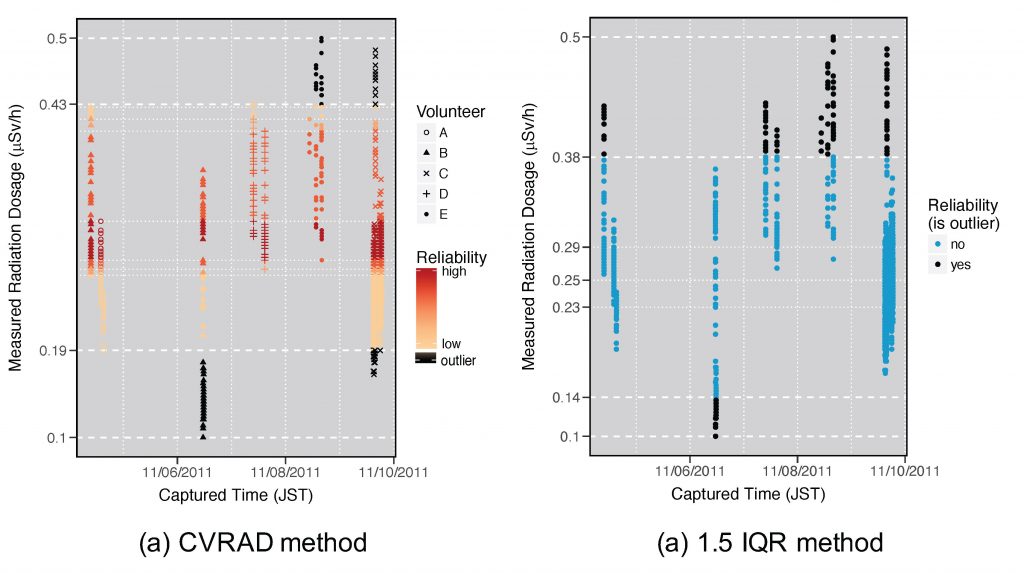
New IJGIS Paper Is Published – “Anomaly Detection for Volunteered Geographic Information: A Case Study of Safecast Data”
A paper titled “Anomaly Detection for Volunteered Geographic Information: A Case Study of Safecast Data” by Dr. Yanan Xin is recently published online.
Volunteered Geographic Information (VGI) is a promising new data source for scientific research. However, many scientists are concerned about the quality of VGI data for research, given the lack of rigorous and systematic quality control procedures. This study contributes to the improvement of VGI quality by proposing a Cross-Volunteer Referencing Anomaly Detection (CVRAD) method to filter anomalous measurements in mobile environmental sensing data, using the crowdsourced Safecast radiation data set as a case study. The method is validated using both official KURAMA car-borne survey data and filtered measurements by Safecast moderators. The validation results demonstrate that the anomaly detection method can successfully identify abnormal values and reduce errors in the VGI data when sufficient volunteers are present; thereby increasing the overall accuracy of the data. The code developed to support the findings of the paper is available in figshare.com.
New Project V2G4CarSharing Is Funded by the SFOE
Our new project “V2G4CarSharing” in collaboration with Hive Power and Mobility is funded by the Swiss Federal Office of Energy (SFOE) mobility research program. The project aims to develop and evaluate optimal strategies to integrate car-sharing and Vehicle-to-Grid (V2G). By integrating car-sharing and V2G, our research will tackle core issues related to the stability of the Swiss power grid and the electrification of the transportation system, thus supporting the fulfillment of the Swiss Energy Strategy 2050.
We Welcome Nina Wiedemann to MIE Lab
Nina Wiedemann joins MIE-Lab as a Ph.D. student. She completed her Master’s degree in Data Science at ETH Zürich and Bachelor’s degree in Cognitive Science from the University of Osnabrück, Germany. We welcome Nina to our team!

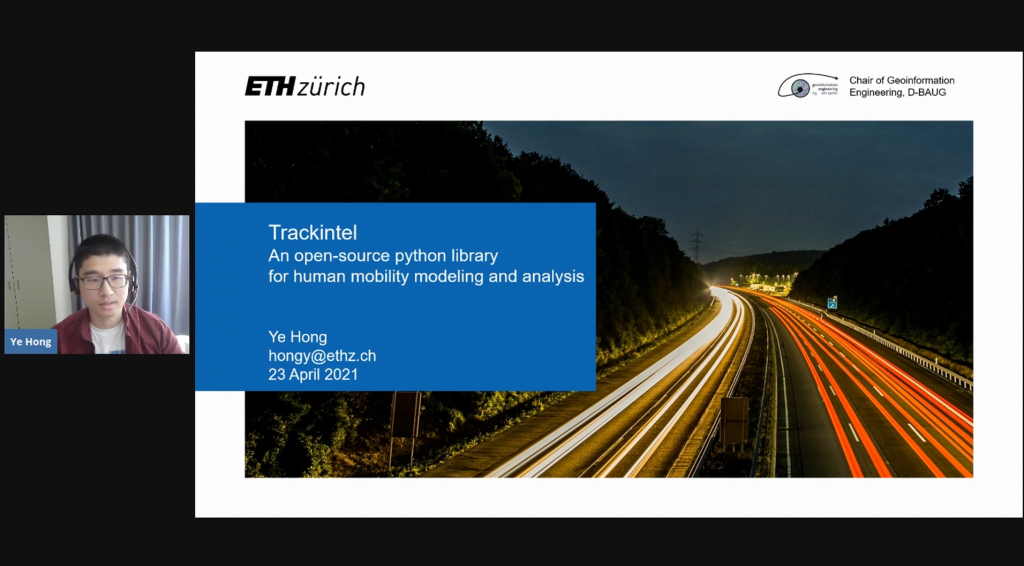
Ye Hong Presented at GeoPython 2021
Ye Hong introduced the trackintel framework at GeoPython 2021. Trackintel is an open-source python framework for human mobility modelling and analysis. Find out more on GitHub.
We Welcome Yatao Zhang to MIE Lab
We welcome Yatao Zhang to our team as a PhD student at the Singapore-ETH Centre. Yatao received his Master of Science degree in Cartography and Geographical Information System from Wuhan University, and a Bachelor of Science degree in Geographical Information Science from Sun Yat-sen University in China.
New Book Chapter Is Published – “Geosmartness for Personalized and Sustainable Future Urban Mobility”.
The book chapter titled Geosmartness for Personalized and Sustainable Future Urban Mobility by Prof. Dr. Martin Raubal, Dr. Dominik Bucher, and Henry Martin from the book Urban Informatics is now available online. This chapter demonstrates how geosmartness, a combination of novel spatial-data sources, computational methods, and geospatial technologies, provides opportunities for scientists to perform large-scale spatio-temporal analyses of mobility patterns as well as to investigate people’s mobile decision making.